Virtual Design Analysis Group is a division of NVentum, LLC.


-CAPTURING HISTORY-
This unique collaborative endeavor; to utilize the latest reality capture technology to document the artifacts, buildings and campus of History San Jose, provides opportunities for private sector, non-profits and institutions of higher education to work together to solve some of today's most pressing engineering issues. The protocol for retrofitting as-built historic facilities and the use of new technologies to preserve our most prized historic treasures are vital to the continued success and expanded influence of our museums.
This blog will document the challenges and successes of this ambitious, one of a kind project.

Monday, May 14, 2012

Making The Case For Historic Documentation

"Historic preservation can -and should- be an important component of any effort to promote sustainable development. The conservation and improvement of our existing built resources, including re-use of historic and older buildings, greening the existing building stock and re-investment in older historic communities is crucial to combating climate change..." Preservation Nation.org

SAN JOSE'S RICH HISTORY
California's First Civilian Settlement- November 29, 1777
California's First State Capital- 1849-1852
California's First Incorporated City- March 27, 1850

San Jose is the third largest city in California and the tenth largest city in the country. Founded in November 1777, El Pueblo de San Jose de Guadalupe was the first civilian town in the Spanish territory of Nueva California. The settlement served as a farming community to support military installations at Monterey and San Francisco, CA. Historic places help define and distinguish our communities by creating a strong sense of identity; understanding our heritage, connecting the stories of past generations to the experiences of today. 

Old Chinatown
(East side of Market Street, from San Fernando to San Carlos Streets)From 1872 to 1887 a large Chinese population lived and prospered in this area. By the late 1800's, downtown businesses were expanding and many of the business leaders wanted to relocate Chinatown. In 1887, after several unsuccessful attempts at relocation, a mysterious fire tore through Chinatown's wooden and brick structures. Within a matter of hours, the entire community was wiped off the map. This historic marker is the last reminder of the community and the people of old Chinatown.

Rare Photo of Old Chinatown
cir.1880/View From Market Street


The Donner-Houghton House
The Donner-Houghton House was built by Sherman Otis Houghton, a well known attorney and politician and in 1881. A former mayor f San Jose, Deputy Clerk of the California Supreme Court and Commissioner of the US Mint at San Francisco, in 1859, Mr. Houghton married Mary Martha Donner a survivor of the Donner Party. 
Donner-Houghton Mansion 2006
The Donner-Houghton home was placed on the National Register of Historic Places in 2002. Plans were being made to move the home to the San Jose History Park.
On the morning of July 9, 2007, the home was almost completely destroyed  by fire.
Donner-Houghton Mansion- July 2007
The Kelley House
Original Kelley House Elevation
at San Jose's Kelley Park
The 5600 Square Foot Kelley House was built in 1912 and was the last historical structure associated with the Kelley Family. The property was once owned by Louise Kelley who inherited it from her father, former San Jose mayor, Lawrence Archer.The 160 acre property was originally named "Lone Oak" was purchased in 1861. The original house burned to the ground in 
1909. The new home was built in the same location in 1910. In 1951, Louise Archer Flavin Kelley sold the house and 63 acres to the City of San Jose for use as a public park, on the condition she be allowed to live in the family home for the rest of her life. She died six months later in February 1952 at the age of 89. 
Kelley Fire 


Kelley House Fire
February 2012
In February 2012, the Kelley House was destroyed by fire. Estimates to restore the home to historic conditions are from $6 to $8 million.

IBM Building #25
IBM Building 25
When IBM erected the Advance Research Building number 25 in 1957, it was the symbol of Silicon Valley innovation. The building was developed to house IBM's top data-storage, who made history with the development of the flying head disc drive. The data technology allowed for online transaction processing, which companies like American Airlines used for real-time reservation systems. In 1958, Factory-Maintenance and management named the building "Plant of The Year" out of 900 sites. The Historic Landmarks Commission named this site is "one of the finest examples of Modern Industrial architecture in Santa Clara County". 
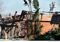
IBM's Historic Building #25
Destroyed by Fire March 2008

The documentation of historic architecture provides insight into the artistry, craftsmanship, culture and technology of our forefathers. Understanding the techniques and technology of the past helps pave the way for the innovations of today and tomorrow. Modern cutting edge sustainable construction technology, the efforts to reduce the carbon footprint of capital facilities and the emergence of LEED technology have their roots in the study of our historic architecture.


For more information on iconic Silicon Valley Architecture, 
Visit our Silicon Valley Blog at www.virtualdesignanalysissiliconvalley.blogspot.com


Tuesday, May 8, 2012

Clarifying BIM

What is BUILDING INFORMATION MODELING?
 The National Institute of Building Sciences defines BIM as
 Building Information Modeling (BIM) utilizes cutting edge digital technology to establish a computable representation of all the physical and functional characteristics of a facility and its related project/life-cycle information, and it is intended to be a repository of information for the facility owner/operator to use and maintain throughout the life-cycle of a facility.

In simple English, BIM technology uses a 3D model as a data base for information about the building and all operating systems; environmental, security, MEP, etc.. The diagram below, courtesy of AEC Infosystems Inc., gives an excellent example of BIM technology. As you can see, the image of the door and door frame have pop-up categories with room for myriad information about the door, the frame and hardware. The information can be retrieved for use at any time and can be altered, changed or edited by the administrator/primary user(s) as necessary.
Detailed examination of the diagram provides insight into the type of information that can be stored and retrieved from a 3D model. The information from the model can be used for operations, planning,  construction, facility retrofits and as-built documentation.
Facility owners can conduct a variety of simulations utilizing the information stored within the 3D model. For example, the diagram above contains a significant amount of information about the construction of the door. In addition to the dimensions of the door, the diagram includes the door's fire rating, acoustical rating, glass inserts, heat transfer rate, etc. This vital information can be used to create a variety of simulations that can help a facility owner decide what types of changes, retrofits or upgrades would provide the best results for the long term operation of a facility. Acoustical simulations, energy simulations, heat transfer simulations can all be conducted within the 3D model. The facility owner/operator can exchange the door in the virtual world, replacing it with a door that has different fire rating, heat transfer rating, different type of glass inserts and conduct simulations for sound, air flow and energy usage. Simulations like these can help facility owner/operators develop strategies to reduce operational cost.
Air contaminants are a critical concern for museums. The quality of the air, the flow, moisture and circulation can have a major impact on exhibits, especially historic items. The ability to test the quality of the air and its impact on the museum environment is crucial to the long term survival of historic artifacts. BIM technology holds the answers to the problems that all museums struggle to address.
Given the detailed information included in the diagram above, imagine what type of information can be included in an entire building that incorporates BIM technology. Windows, doors, walls, ceilings, floors, mechanical systems, electrical systems, plumbing, roofing, landscaping, there is no  aspect of a building that cannot benefit from the inclusion of BIM technology.

Tuesday, May 1, 2012

Documenting Historic Sites


Laser scanning is not an untested technology when it comes to the documentation of archaeological sites. There are currently dozens and dozens of preservation projects underway around world utilizing laser scanning technology to capture and store data. Organizations like the Center For Advance Spatial Technologies, CyARK and Universities from all over the world are working with lasers and 3D models to document and preserve historic structures and sites for future generations.

Here are just some of the historic preservation projects currently underway around the world:

CAST Projects
(Center For Advance Spatial Technologies)
Project: Laser scanning of Machu Picchu, Peru. A UNESCO World Heritage Site
Organization: Center For Advance Spatial Technologies w/University of California Los Angeles' Cotson Institute for Archaeology. "Computer Modeling of Heritage Resources Field Program" 

Project: Prairie Grove Battlefield State Park, Historic Civil War Site
Organization: Center For Advance Spatial Technologies- University
of Arkansas Honors College


Project: "Visualizing The Roman City: Ostia Antica"
Organization: Center For Advance Spatial Technologies w/ University
of Arkansas Honors College


CyARK Preservation Projects


Church of Sao Francisco
Church of Sao Francisco- Bahia Brazil, 1538
Mt. Rushmore- South Dakota
Medieval Bridge at Regensburg Germany
The Presidio of San Francisco
The Cathedral of Beauvais, Beauvais France
Ruins at Chichen Itza, Mexico
The Ramesseum at Ancient Thebes, Egypt
Deadwood, South Dakota
Temple at Angkor, Cambodia
The Ruins at Pompeii
Mesa Verde Ruins
Roman Baths, Weibenburg, Bavaria
Rapa Nui- Easter Island Monolith
Qal' at al-Bahrain- (14th Century Portuguese Fort)
Mesa Verde National Park, Colorado...(in collaboration w/Texas Tech University, UC Berkeley and National Park Service)


Chichen Itza-
 Mayan Ruins


Chichen Laser Scan


These are just some of the historic preservation projects currently underway around the world that are utilizing laser scanning technology for documentation purposes. Given the number and the extent of the historic documentation projects listed above, what makes "Capturing History" such a unique project? What is History San Jose, NVentum LLC. and Evergreen Valley College doing that sets this project apart from all others?

Pasetta House
Laser Scan by Ken Hanna, NVentum, LLC.

The Difference is BIM
Capturing History utilizes laser technology as the foundation of our project in the same manner as other documentation projects. Laser scanning provides fast accurate documentation for condition monitoring, preservation, clash detection and virtual reconstruction. However, this is just scratching the surface of what this technology can be used for. As mentioned in many of my previous post, one of the major objectives of this project is to create a BIM model of the historic buildings and the History Park' s 14 acre campus.
Blacksmith's Shed and Trolley Barn
Laser Scan by Ken Hanna, NVentum, LLC

A complete BIM model of the HSJ campus and facilities will provide a shared platform for the day to day maintenance, management and operations of the museum.
Operations staff will use the 3D model for virtual expansion of the park grounds, to monitor mechanical systems, plan/install sustainable energy upgrades, conduct facility performance simulations, or to schedule maintenance and repairs.
Administrative staff will use the 3D model as a project calendar and to schedule events
Marketing staff will use the model as a sales tool, a data base and/or online exhibit.
Pasetta House
Scan by Ken Hanna
Safety/Security staff will use the 3D model to monitor the museum's assets, emergency planning, traffic control, fire inspection/permits, seismic monitoring/retrofits, etc.

The Capturing History project answers the question, "what now?... Now that I have this 3D model, what can I do with it?"

Pasetta House
Pasetta Porch/Entrance